

To find your property line for free, start by examining your title deed, which details boundary descriptions. Verify this against plat maps available on local government websites. Use county records to access digital copies of past surveys. Employ mapping apps like LandGlide for GPS overlays; however, cross-check with official documents for precision. DIY measurement involves using a tape measure from a defined point in the deed, but confirm findings with legal or surveyor records, as accuracy is essential. Understanding these resources enables you to confidently ascertain property lines and prevent disputes, revealing further insights as you explore more.
Key Takeaways
- Access local government websites for free digital property records, including plat maps and deeds.
- Utilize interactive mapping tools provided by county assessor’s offices for property boundary information.
- Search county records online for detailed property line information and digital copies.
- Explore GIS mapping tools for visual representation of property boundaries.
- Leverage free mapping apps like LandGlide and Regrid for GPS-based property line overlays.
Understanding Property Lines
Understanding property lines is vital because they define the legal boundaries of land ownership and are often based on either visible markers or detailed legal records. These boundaries are essential for maintaining clarity in land ownership and preventing disputes. To find your property lines, it’s important to understand how various tools and records can assist you in this process.
Start by examining the legal description found within your title deed. This document outlines the property boundaries in precise terms, often referencing specific points and measurements. You can also access property records online through your local government’s website to obtain a copy of your plat map. A plat map provides a visual representation of the subdivision of land, showing detailed layouts of individual parcels.
Consider using a land surveyor if you need a professional assessment of your property lines. They use advanced tools to provide precise measurements, guaranteeing your understanding of the property’s legal limits is accurate. This can be particularly useful if visible markers like fences or natural features don’t align with the legal description.
For those who prefer a digital approach, property lines online tools are available. They can offer an initial overview, but remember they may not always be as accurate as official records. Always cross-reference any online findings with your title deed and plat map.
Ultimately, understanding property lines through these key resources guarantees you have a thorough grasp of your land’s legal boundaries, aiding in communication with mortgage lenders and title insurance companies. This proactive approach secures your ownership rights and prevents future disputes.
Importance of Knowing Boundaries
Understanding your property boundaries is essential to prevent disputes with neighbors, which can escalate into expensive legal battles and damage relationships. Accurate knowledge of these lines guarantees your home improvements and landscaping projects comply with local zoning laws, thereby avoiding costly encroachments. By securing precise boundary information, you assure adherence to legal requirements, safeguarding your property rights and financial interests.
Preventing Boundary Disputes
While disputes over property boundaries can be a source of tension between neighbors, knowing your property’s exact lines greatly minimizes these conflicts. Accurate identification of your property line information is vital to prevent misunderstandings. With clear legal boundaries, you can plan landscaping or home improvements without encroaching on adjacent properties. This not only fosters good neighborly relations but also solidifies any boundary line agreement, guaranteeing all parties respect established lines.
Understanding your property deed and verifying it against physical markers are essential steps to avoid discrepancies. Title insurance policies often don’t cover boundary disputes, making it even more important to have concrete property line information. Here are some key reasons to prioritize knowing your boundaries:
- Prevent Misunderstandings: Clear boundaries help avoid potential conflicts with neighbors.
- Accurate Assessments: Knowing property lines guarantees precise assessments during home purchases.
- Financial Protection: Avoid costly legal disputes and potential financial losses.
- Transaction Efficiency: Verified boundaries streamline dealings with mortgage lenders and insurance companies.
Ensuring Legal Compliance
To guarantee legal compliance with property boundaries, it’s important to accurately identify and understand the precise limits of your land. Knowing your property lines helps prevent legal disputes with neighbors over potential encroachments, which can lead to costly litigation. By clearly defining your property boundaries, you guarantee adherence to local zoning laws and regulations, significant when planning home improvements or landscaping projects.
| Aspect | Importance | Action Required |
|---|---|---|
| Property Lines | Prevents disputes and guarantees legal land use | Verify through deed description |
| Legal Compliance | Meets zoning laws and avoids penalties | Consult local assessors office |
| Title Insurance | Protects against boundary disputes affecting coverage | Confirm accurate boundary definitions |
| Property Boundaries | Establishes clear limits for mortgage and resale assessments | Review and verify property deeds |
| Zoning Laws | Governs land use and permissible activities | Align projects with legal standards |
Accurate property lines are also important for obtaining title insurance; any discrepancies can affect your coverage and claims. Additionally, understanding your property boundaries aids in accurate property value assessment, significant for mortgage applications and resale potential. Legal descriptions in property deeds often reference specific markers, making it important to verify these details. Engage with your local assessors office for precise measurements, guaranteeing your property’s legal standing.
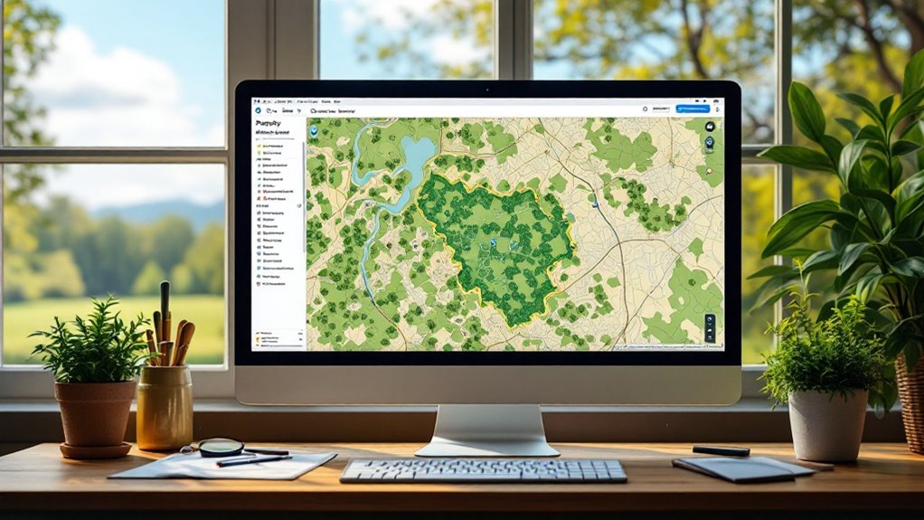
Use a Property Line Map

Property line maps, often referred to as plats, serve as crucial tools for accurately identifying the boundaries of your land. These maps visually illustrate boundary lines and environmental features, enabling you to gain a precise understanding of your property’s layout. Accessible through local government offices, property line maps are invaluable for confirming boundary lines in conjunction with legal descriptions found in property deeds. By cross-referencing these resources, you guarantee clarity and precision in defining your land’s extents.
Most counties now offer the convenience of online access to property line maps. This digital availability allows you to view your boundary lines without leaving the comfort of your home. Whether you’re evaluating your property for a new fence or resolving potential disputes with neighbors, plats provide essential insights.
Key advantages of using property line maps include:
- Visual Clarity: Plats offer a visual representation of your property’s boundaries, making them easier to comprehend than textual descriptions alone.
- Accessibility: Obtainable from local government offices, many maps are also available online, simplifying the process of gathering boundary information.
- Dispute Prevention: Understanding shared boundary agreements through plats can help avert conflicts with neighboring property owners.
- Cross-Referencing: By comparing plats with legal descriptions in property deeds, you achieve a thorough understanding of your property’s limits.
Utilizing property line maps offers a methodical approach to identifying and verifying your boundary lines. This proactive step aids in maintaining harmonious neighbor relations and guarantees your property is accurately accounted for. By integrating these resources into your property management strategy, you strengthen your understanding of your land’s true dimensions.
Review the Property Deed
A property deed stands as a significant legal document delineating the precise boundaries of your land, often through detailed measurements, shapes, and specific landmarks. This document serves as the definitive guide to understanding your property’s legal description, playing a key role in land surveying. Within its text, you may find terms such as “metes and bounds,” which describe the perimeter by referencing physical features and distances. Such descriptions are fundamental in establishing clear property lines and preventing future boundary disputes.
When reviewing your property deed, it is important to verify the accuracy of the legal description it provides. Outdated deeds may refer to non-existent landmarks or rely on old surveys, potentially leading to misunderstandings about your actual property lines. By cross-referencing the information in the deed with modern plat maps, you can develop a more accurate understanding of your property’s boundaries. Plat maps offer a visual representation, bringing the descriptions within the deed to life and confirming the property’s true extent.
Keep your property deed readily accessible, as it is crucial for legal proceedings and clarifying boundaries when disputes arise. This document not only establishes the extent of your property but also serves as a reference point for any land surveying efforts that may be required. Verifying the deed’s details are current and checked against recent surveys provides peace of mind and legal assurance. Ultimately, a thorough review of your property deed fortifies your knowledge of your property lines and safeguards your land rights.
Locate Existing Surveys

After reviewing your property deed for legal descriptions, it’s important to locate any existing surveys to further clarify your property boundaries. Surveys offer precise details about your property lines, easements, and any restrictions that might affect your land. These documents, often conducted during property transactions, can be invaluable in understanding the exact dimensions and limits of your existing property.
Here’s how you can find these surveys:
- Check with your mortgage lender or title company: If you purchased your property recently, these entities might have conducted a survey during the transaction process and can provide you with a copy.
- Visit the local government offices: Specifically, head to the tax assessor’s office. They typically maintain thorough records of property surveys, accessible in person or via their online portals.
- Search for county records: County records can reveal detailed information about your property lines. Many counties offer digital copies of surveys and plat maps, allowing you to explore the boundaries without any cost.
- Examine the deed or plat: While reviewing existing surveys, verify you check the date and accuracy. Outdated surveys may reference landmarks that no longer exist or reflect changes in local geography.
Accessing these resources not only provides clarity but also guarantees you rely on accurate and current data. Remember, while surveys are often available through various channels, always verify the information’s timeliness and precision to avoid any potential discrepancies regarding your property boundaries. This due diligence will empower you to establish a solid understanding of your property lines.
DIY Measurement Techniques
To start determining your property boundaries with DIY measurement techniques, begin by identifying a clearly defined point from your property’s deed description, such as a corner marker or a distinctive landmark. This initial reference guarantees your DIY measurements will accurately reflect where your property begins and ends.
Once you’ve established the starting point, use a tape measure to find property lines by measuring straight distances to the property’s edges. As you measure, place stakes at key locations to visualize these boundaries. Survey pins, if present, are a reliable option for confirming these points. They’re often metal stakes embedded in the ground at significant boundary corners.
DIY measurements should be compared against official plat maps or any prior surveys you have access to. This step is vital for verifying the precision of your findings and adjusting your markers if discrepancies arise. While natural features like trees and streams can serve as informal boundary indicators, confirm any assumptions based on them through official documentation to avoid inaccuracies.
Online Resources and Tools
To accurately identify your property line, start by accessing local government websites that offer free digital records like plat maps and deeds. Utilize interactive mapping tools from the county assessor’s office and GIS websites to view detailed boundary information from the comfort of your home. Verify you cross-check digital findings with official documents to maintain accuracy and reliability.
Accessing County Records
Maneuvering the intricacies of property boundaries can be greatly simplified by utilizing county records available online. Many county websites offer free access to essential property records, including plat maps and legal descriptions, enabling you to view your property lines without leaving your home. Start by visiting your local assessor’s office website, which often contains a digital database where you can search for property lines using your address or parcel number.
Several counties also provide GIS mapping tools, which are invaluable for visually representing property boundaries and adjacent lots. With GIS mapping tools, you can:
- Explore interactive maps to understand the precise location of your property lines.
- Download property line documents, such as deeds and surveys, directly from county websites.
- Access detailed plat maps illustrating your property’s specific dimensions and layout.
- Obtain legal descriptions that define your land’s boundaries.
It’s essential to check multiple sources since not all counties have fully digitized their records. In some cases, accessing complete information might require a physical visit to local offices. By leveraging these online resources, you can efficiently determine your property lines with confidence and accuracy.
Utilizing Mapping Apps
Revealing the potential of mapping apps can greatly enhance your understanding of property boundaries. Many counties offer GIS tools online, granting you access to detailed property line information without financial burden. Apps like LandGlide and Regrid provide GPS-based overlays of property lines, allowing real-time boundary visualization. These platforms often include a free trial, enabling you to explore their services thoroughly before any commitment.
Here’s a snapshot of what you can expect:
| App/Tool | Features | Cost |
|---|---|---|
| LandGlide | GPS-based property lines | Free trial |
| Regrid | Real-time boundary overlays | Free trial |
| GIS Online | Detailed boundary maps | Free |
Google Maps also offers a glimpse into property lines when specific addresses are entered, although accuracy and availability might differ based on location. Meanwhile, online property records and plat maps are accessible via local government websites, providing essential boundary insights at no cost. Platforms like Zillow and Realtor.com supplement this data by including lot dimensions and neighborhood layouts in listings. By leveraging these mapping apps and online tools, you can efficiently navigate and verify your property boundaries with precision and authority.
Exploring Online Plat Maps
Why navigate the complexities of property lines when online plat maps offer a straightforward solution? These digital resources provide a precise visual representation of property boundaries, accessible through local government websites or assessor’s offices at no cost. By utilizing online plat maps, you gain insights into essential details, such as lot dimensions and neighboring properties, which are fundamental for accurate boundary identification.
To leverage these resources, begin by visiting your local county’s GIS portal or property records webpage. Many counties have digitized their plat maps, allowing you to view and print them conveniently from home. Understanding scale and symbols used in these maps is critical for interpreting property boundaries correctly and ensuring compliance with local zoning regulations.
Consider the following benefits of exploring online plat maps:
- Cost-Effective: Access detailed maps without spending a dime.
- Comprehensive Data: Includes geographical features, lot dimensions, and adjacent properties.
- User-Friendly: Navigate and print maps easily from local government websites.
- Accurate Analysis: Understand property boundaries through precise scale and symbol interpretation.
Handling Property Line Disputes
When property line disputes arise, it is imperative to address them promptly and decisively to prevent further complications. Start by clarifying property lines, a process that often requires the expertise of a licensed surveyor. A licensed surveyor can provide an accurate assessment of your property’s boundaries, which is essential in resolving boundary disputes. Their professional measurements and reports hold significant weight in legal contexts and can serve as definitive evidence of property lines.
Engage in open communication with your neighbors to discuss any boundary concerns. This approach can help reach amicable resolutions without escalating into formal disputes. However, should disagreements persist, documenting findings becomes necessary. Keep detailed records of surveys, any correspondence with neighbors, and other relevant documents. Such documentation is critical for legal protection and clarity in ongoing disputes.
If boundary disputes become contentious, securing legal counsel might be necessary, especially in cases involving encroachments or prescriptive easements. These situations can complicate property ownership rights, and having an attorney’s guidance guarantees you maneuver the legal landscape effectively. Legal counsel can help interpret survey results, provide advice on property ownership rights, and represent your interests in court if necessary.
While maneuvering through these disputes, remember that proactive measures—such as hiring a licensed surveyor and maintaining open communication—can prevent misunderstandings from escalating. By addressing concerns with precision and documenting findings meticulously, you safeguard your property ownership rights and facilitate a smoother resolution of any boundary disputes. This structured approach helps maintain good neighborly relations and protects your investment.
Conclusion
Charting property lines can feel like untangling a complex web, yet with precision and careful analysis, you’ll gain clarity. Use maps, deeds, and surveys to demystify boundaries; these tools transform confusion into certainty. DIY techniques and online resources empower you to act with authority. Remember, understanding boundaries fosters neighborly harmony, preventing disputes before they arise. In this balance of technical skill and interpersonal awareness, you’ll find both certainty and peace on your property.